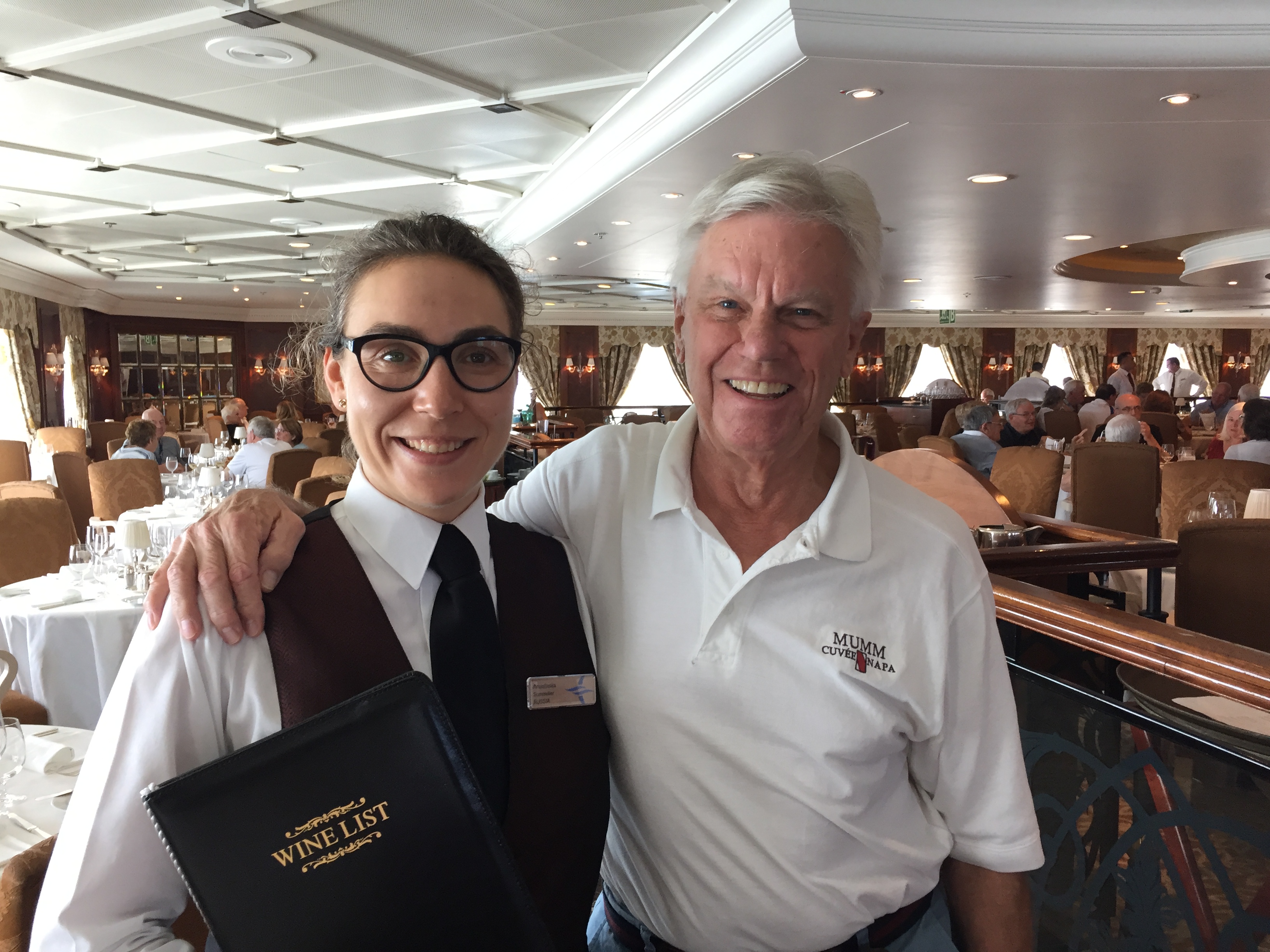
Before we discuss the wonderful day we have in this beautiful island, let us start this post with a picture of one of our favorite people on this cruise. Her name is Anastasia (she taught us how to pronounce her name in Russian: it is Ah nah stah see’ a) and she is a sommelier for Oceania Cruises. She was on the ship when we boarded in Miami, and was on the ship until Honolulu. She is from Russia, and it was a delight to talk with her throughout the trip. She is a perfect representative of the wonderful men and women that work on this ship, and we wanted to highlight her in this blog.
We arrive in the bay between the islands of Lanai and Mau. It’s around 8:00am when we anchor off Lahaina and we will tender into that town for all the excursions. Ours is called Panoramic Maui and Iao Valley, and begins at 8:30 in Insignia Lounge. It will only be a 2 ½ hour tour, and we chose it so that we could spend some time in Lahaina.
We depart from near the wharf right in the center of town and are greeted by our guide Roy.

We are heading south down the leeward (west) coast of the island in the area known as West Maui. The island of Maui was originally two volcanic islands, but an eruption approximately 10,000 years ago created an isthmus that connected the two islands. This is not to be confused with the county of Maui, which includes that island and the islands of Molokai, Lanai and Kaho’olawe.

Maui has a very interesting history, both prior to and subsequent to the arrival of Europeans. Polynesians were the first to arrive a thousand years ago from Tahiti and the Marquesas Islands. King Kamehameha I fought a battle in 1790 to subdue Maui, but that was inconclusive. He returned a few years later and was successful in incorporating Maui as part of his unification of the Hawaiian Islands. The town of Lahaina actually served as the capital of the Kingdom of Hawaii for a period in the early 1800s.
Captain James Cook did come to Maui on one of his expeditions in 1778 but couldn’t find a suitable place to land. European development really began to take off with the arrival of missionaries from New England in 1823. Here is what Wikipedia writes about this period of history: “They clothed the natives, banned them from dancing hula, and greatly altered the culture. The missionaries taught reading and writing, created the 12-letter Hawaiian alphabet, started a printing press in Lahaina, and began writing the islands’ history, which until then was transmitted orally. Ironically, the missionaries both altered and preserved the native culture. The religious work altered the culture while the literacy efforts preserved native history and language. Missionaries started the first school in Lahaina, which still exists today: Lahainaluna Mission School, which opened in 1831.
“At the height of the whaling era (1843–1860), Lahaina was a major center. In one season over 400 ships visited with up to 100 anchored at one time in Lāhainā Roads. Ships tended to stay for weeks rather than days, fostering extended drinking and the rise of prostitution, against which the missionaries vainly battled. Whaling declined steeply at the end of the 19th century as petroleum replaced whale oil.
“Kamehameha’s descendants reigned until 1872. They were followed by rulers from another ancient family of chiefs, including Queen Liliʻuokalani, deposed in the 1893 when overthrow of the Kingdom of Hawaii by American business interests. One year later, the Republic of Hawaii was founded. The island was annexed by the United States in 1898 and made a territory in 1900. Hawaiʻi became the 50th U.S. state in 1959.”
Besides the whaling industry, the economic history is centered around the raising of sugar cane and, later, pineapple. The sugar industry took place on several Hawaiian islands, but was theeconomic foundation of Maui. The industry got its start in 1878 when the Hawaiian kingdom issued the Great Mahele, an edict allowing non-Hawaiians to purchase land. In the annals of unintended consequences, this decision has to be ranked right up there near the top. The result was a land rush, as the demand for sugar due to the California Gold Rush soared. The price for sugar soon dropped as supply from the Caribbean and South America grew, and many of these early investors went bust.
It was the American Civil War that caused prices to skyrocket and consequently grew the industry. A man named Spreckels from California, already a millionaire sugar baron there, and two local men who were sons of the original missionaries that had come to the island are among the five sugar barons that pretty much controlled the industry in Maui and most of Hawaii.
These sugar barons were not unlike the robber barons of the continental United States during the latter decades of the 19thcentury. Their power was such that they engineered the downfall of Hawaiian royalty, induced the United States government to intervene and eventually annex Hawaii. Sugar ruled.
Nothing is forever, and as the state economy grew and diversified, other crops came into favor, such as pineapple. Statehood brought the introduction of federal laws, and slowly but very surely, sugar from Hawaii became uncompetitive. The last sugar mill closed in 2016, and the 36,000 acres in Maui where it grew are still in the hands of the owner, who has pledged to keep the acreage in agriculture. There was a cattle industry, developed in a previous era by the sugar companies in order to feed their employees, almost all of whom were immigrants. Those ranches closed in 1975.
Maui is trying very hard to retain its rural character in order to maintain its attraction to tourists. There is an effort in agriculture experimentation on a few acres of the former sugar plantation to see what crops might be profitably raised.


Okay, sorry for the long diversion from the tour, but our guide’s narration prompted my research and I wanted to share some of what I learned. Now we are heading south, and to our left we see stonewalls. Guide Roy tells us that this was one of the original roads, a wagon trail built in 1910 by prisoners. It wasn’t paved until the 1950s and has since been replaced by the road we are riding on.

The road curves left and starts up into the valley through the village of Waikapu. The sugar mill that was there was closed in 1999, replaced with million dollar homes. After we pass through that village, we take a left and continue up another road into Iao Valley State Park. Here is part of the Wikipedia entry for a description: “The state park is located on 6.2 acres (2.5 ha) at the end of Iao Valley Road (Highway 32). The Iao Needle (Kūkaemoku) is a famous landmark in the state park, a vegetation-covered lava remnant rising 1,200 feet (370 m) from the valley floor or 2,250 feet (690 m) when measured from sea level. The “needle” itself is an illusion, and is in reality a sharp ridge that gives the appearance of being a spire when viewed end-on. The needle is an extension of and surrounded by the cliffs of the West Maui Mountains, an extinct volcano.

“Iao Valley is covered in dense rainforest, most of which consists of introduced vegetation on the valley floor. The Puʻu Kukui summit area at the valley’s head receives an average 386 inches of rainfall per year, making it the state’s second wettest location after Mount Waiʻaleʻale. Much of this rainfall ends up flowing into the Iao Stream. Trails in the State Park run alongside Iao Stream and through the forest.
“The Hawaiian god Kāne is considered to be the procreator and the provider of life. He is associated with wai (fresh water) as well as clouds, rain, streams, and springs. Kanaloa, the Hawaiian god of the underworld, is represented by the phallic stone of the Iao Needle.
“Kapawa, the king of Hawaiʻi prior to Pili, was buried here. Maui’s ruler Kakaʻe, in the late 15th century, designated Iao Valley as an aliʻi burial ground. The remains were buried in secret places. In 1790, the Battle of Kepaniwai took place there, in which Kamehameha the Great defeated Kalanikūpule and the Maui army during his campaign to unify the islands. The battle was said to be so bloody that dead bodies blocked Iao Stream, and the battle site was named Kepaniwai (‘the damming of the waters’).”


We walk around here for about forty-five minutes. It is unbelievably lush and green, and there are quite a few of us tourists enjoying it. On our way out, Roy tells us that Hawaiians believe that the valley is here for food and shelter for the future and has been sacred with the Kings that are buried here.
Roy’s narration continues as we exit the valley back the way we came. He speaks of the immigrant populations brought to Maui, the last four to work in the sugar industry. They came in a specific order, each group’s people recruited for a specific reason. The order runs: Polynesians, missionaries, Chinese, Japanese, Filipinos, Portugese and Puerto Ricans. Each group located in their own separate villages.
He speaks of the surrounding islands that are also part of Maui County. The first is Kahoolawe. Because there are no regular water sources available, this 11 mile x 6 mile, 45 square mile island has never been extensively inhabited, nor have agricultural operations been successfully operated. Here is part of the Wikipedia entry of what happened when WWII broke out: “On December 7, 1941, after the Imperial Japanese Navy attacked Pearl Harbor and Oahu, the U.S. Army declared martial law throughout Hawaii, and it used Kahoʻolawe as a place to train American soldiers and Marines headed west to engage in the War in the Pacific. The use of Kahoʻolawe as a bombing range was believed to be critical, since the United States was executing a new type of war in the Pacific Islands. Their success depended on accurate naval gunfire support that suppressed or destroyed enemy positions as U.S. Marines and soldiers struggled to get ashore. Thousands of soldiers, sailors, Marines, airmen, and coastguardsmen prepared on Kahoʻolawe for the brutal and costly assaults on islands such as the Gilbert and Marshall Islands, the Marianas and Pelileu, New Guinea, et cetera, in the Western Pacific.
“Military and naval training on Kahoʻolawe continued following World War II. During the Korean War, warplanes from aircraft carriers played a critical role in attacking enemy airfields, convoys, and troop staging areas. Mock-ups of airfields, military camps, and vehicles were constructed on Kahoʻolawe, and while pilots were preparing for war at Barbers Point Naval Air Station on Oʻahu, they practiced spotting and hitting the mock-ups at Kahoʻolawe. Similar training took place throughout the Cold War and during the War in Vietnam, with mock-ups of aircraft, radarinstallations, gun mounts, and surface-to-air missile sites being placed across this island for pilots and bombardiersto use in their training.”
In 1990, after a great deal of civilian protesting and pressure from the Hawaii Congressional delegation, President George H.W. Bush ordered a halt to the use of the island by the armed services. In 1993, the island was turned over to the State of Hawaii. Continuing the Wikipedia entry: “From 1998 to 2003, the U.S. Navy executed a large-scale, but limited removal of unexploded ordnance and other environmental hazards from Kahoʻolawe. Since the clearance did not completely remove all the hazardous and dangerous materials from the island, a residual level of danger remains.”
Lanai is another island in Maui County, west of Maui Island. It only has 3,000 residents, and presently the island is 97% owned by billionaire Larry Ellison of Oracle, who purchased it in 2012 for $300 million. He purchased it from a guy who owned Castle & Cook, which in turn owned Dole Foods. James Dole had purchased the island in the 1920s and developed the world’s largest pineapple plantation on it. Pineapple production had ceased in 1992, but is still nicknamed “Pineapple Island.”
Ellison’s plans are to develop the island into a resort and reportedly plans to spend up to half a billion dollars doing so. The lack of water will be the problem, which it always has been. Apparently, development has slowed until Ellison thoroughly weighs his options, all of them expensive.


Molokai is the third island our guide mentions. It is nicknamed the “Friendly Isle,” but from what our guide told us, this is a big misnomer. Only 4,800 people live on this island, which is as large as the island of Maui. There was a huge ranch at one time that had morphed into a resort. The locals kept up enough vandalism, protests and hostility to convince the owners of Molokai Ranch to shut the whole operation down in September of 2017 and put their 55,575-acre property up for sale for $260 million. The state of Hawaii pretty much administers the island.

Perhaps all of this turmoil has its origin in the past history of one side of the island where the Kilawao leper colony was located. The Wikipedia entry has as good a description as any about this installation: “The legislature passed a control act requiring quarantine of people with leprosy. The government established Kalawao located on the isolated Kalaupapa peninsula on the northern side of Molokaʻi, followed by Kalaupapa as the sites of a leper colony that operated from 1866 to 1969. Because Kalaupapa had a better climate and sea access, it developed as the main community. A research hospital was developed at Kalawao. The population of these settlements reached a peak of 1100 shortly after the turn of the 20th century.
“In total over the decades, more than 8500 men, women and children living throughout the Hawaiian Islands and diagnosed with leprosy were exiled to the colony by the Hawaiian government and legally declared dead. This public health measure was continued after the Kingdom became a U.S. territory. Patients were not allowed to leave the settlement nor have visitors and had to live out their days here. In the 21st century, there are no persons on the island with active cases of leprosy, which has been controlled through medication, but some former patients chose to continue to live in the settlement after its official closure.
“Pater Damiaan de Veuster, a Belgian priest of the Congregation of the Sacred Hearts of Jesus and Mary served as a missionary for 16 years in the communities of sufferers of leprosy. Joseph Dutton, who served in the 13th Wisconsin Volunteer Infantry Regiment during the American Civil War and converted to Roman Catholicism in 1883, came to Molokaʻi in 1886 to help Pater Damiaan and the rest of the population who suffered from leprosy. He stayed there until his own death in 1889. Mother Marianne Cope of the Sisters of Saint Francis of Syracuse, New York, brought six of her Sisters to work in Hawaiʻi with leprosy sufferers in the late 19th century, also serving on Molokaʻi. Both Father Damiaan and Mother Marianne have been canonized as Saints by the Roman Catholic Church for their charitable work and devotion to sufferers of leprosy. In December 2015, the cause of Joseph Dutton was formally opened, obtaining him the title Servant of God.” This is the same Father Damiaan whose statue is in front of the Hawaii State Capitol building in Honolulu.
Well, we arrive back in Lahaina (which in Hawaiian means “merciless and cruel sun” after the lack of rain on that side of the island) right around lunchtime. As we drive down Wainee Street, Roy points out various buildings in this village of 12,000, including Waiola Congregational Church, significant because of the history of the town.

Here is one description of the period of town history when “provisioning” whaling ships was the principal activity of the community: “Whaling ships hunting sperm whales in the Pacific began to arrive in Hawaiʻi in 1819, and many
ships anchored in Honolulu and Lahaina. The impact of the whaling fleets on the Hawaiian Islands during the reign of Kamehameha III (1825–1854) shaped the entire Hawaiian economy and was the primary source of income for the islands until the discovery of oil in Titusville, Pennsylvania in 1859 and the onset of the American Civil War (1861–1865).
“Ships would generally seek repairs in Honolulu, but captains preferred anchoring off Lahaina because of its easy access from the Lahaina Roads and for the fresh provisions available in town. According to Henry L. Sheldon, “the business of the entire population was the furnishing of supplies to whalers and entertaining the crews”. Sailors who had been hunting whales for months at a time went to Lahaina to drink grog and meet women.
“By 1825 a kapu prohibiting women from going out to ships for the purpose of prostitution was proclaimed by the Hawaiian chiefs (ali’i ). Enraged that they could not cajole, coax, or coerce Hawaiian women into violating the kapu, the sailors turned their frustrations on the American missionaries, whom they blamed for the emergence of this new unreasonably strict moral law.
“Whalers opposed any rules governing alcohol and prostitution, and blamed missionaries for influencing the Kingdom of Hawaii to enforce such rules. Riots broke out at least four times—in 1825, 1826, 1827, and 1843. In the 1827 riots, sailors on the John Palmer fired their cannons at the home of missionary William Richards and threatened the safety of the community.
“Queen Kaʻahumanu (1768–1832) visited Maui in February 1832, just months before she died, to support the construction of a new fort to protect the town from whalers. With her help, Hoapili (1775–1840), Royal Governor of Maui, built the fort on the Lahaina waterfront and it was completed within a month.Sailors who docked at Lahaina were subject to a sunset curfew; it they did not return to their ship when the drums sounded they would be imprisoned in the fort.” This quote has been lifted from lahainaharbor.com
Sounds like a wild place for about thirty years or so, much to the chagrin of the missionaries who had come to Hawaii to convert the Hawaiians. The street fronting the harbor is Front Street, and Roy tells us that in the whaling days, the street was full of bars and brothels and was known to the locals as Rotten Street.
Times have certainly changed. Today Lahaina is strictly a tourist town. Strictly. Shops and restaurants are everywhere. A shopping mall as well. Guide Roy also calls it the art capital of Hawaii. It’s cute and the shops look like they have good quality stuff, but we are not in the market. We walk around for a few minutes but aren’t inspired, so we do not tour much of the town.

We do have lunch at an open-air restaurant on Wharf Street named the Pioneer Inn. It is downright delicious, and we can tell we are back in the States because the portions are very generous. Cathy and I share an enormous order of ceviche, so large that we could have made it the entire lunch. Cathy enjoys delicious fish tacos and Steve has Fish and Chips with pineapple coleslaw. Iced tea finishes off a great meal.
After lunch we return to the Tourist Center where we began our day in town. We browse the small gift shop. Then we go upstairs to their museum. What a fine and interesting collection we find there. We spend twenty minutes or so going through the exhibits and pick up a good feel for the history of the town and its place in Hawaiian history.


Before our great guide Roy sent us off from the bus, he mentioned that the pocket park that is located next to the Tourist Center has the world’s second largest banyan tree that has been growing there since sometime in the 1800s. We are intrigued and go out to investigate. Oh my, it is huge – and complex – with at least a dozen shoots falling to the ground where they take root. Steve runs around taking pictures of this amazing natural sight.

But we are beginning to wilt. Lunch always seems to do that to us. Cathy parks herself on a bench to listen to a guy playing a flute while Steve gets just a few more pictures, specifically of Lanai and Molokai and the harbor area, including the oldest lighthouse in Hawaii.


Then we head back to the ship, which leave Au’Au Bay at 5:00pm for the 164 nautical mile sail to Nawiliwili, Kauai, our last stop in Hawaii.


We have been awestruck at the beauty of our 50thstate so far. Can’t imagine what Kauai has in store for us!


eddie
June 25, 2018Good stuff, very interesting, I had no idea Hawaii had so much rich history…what a beautiful island…safe travels
Eddie
Pat Kohl
June 25, 2018Oh, wow! What a beautiful place! I didn’t know about its history, either, so thanks for the interesting info. And what a treat to see the world’s (the World’s!) second-largest banyan tree. Amazing!